
Parents worried about the risk of infection when their children return to school can use a mapping tool developed by the Ontario research institute ICES to see what neighbourhoods in the city present the biggest risk based on vaccination rates and the number of positive COVID-19 tests.
The least risk of infection, according to the ICES data, is in Hespeler, and west Galt.
The neighbourhood with the highest risk of infection is in the River Mill subdivision in west Hespeler.
The data provided by ICES is broken down by postal code into what’s called a forward sortation area (FSA) with each representing a neighourhood risk group.
On the low end of the scale, a one represents a high number of COVID-19 infections and a 10 represents a low number of COVID-19 infections.
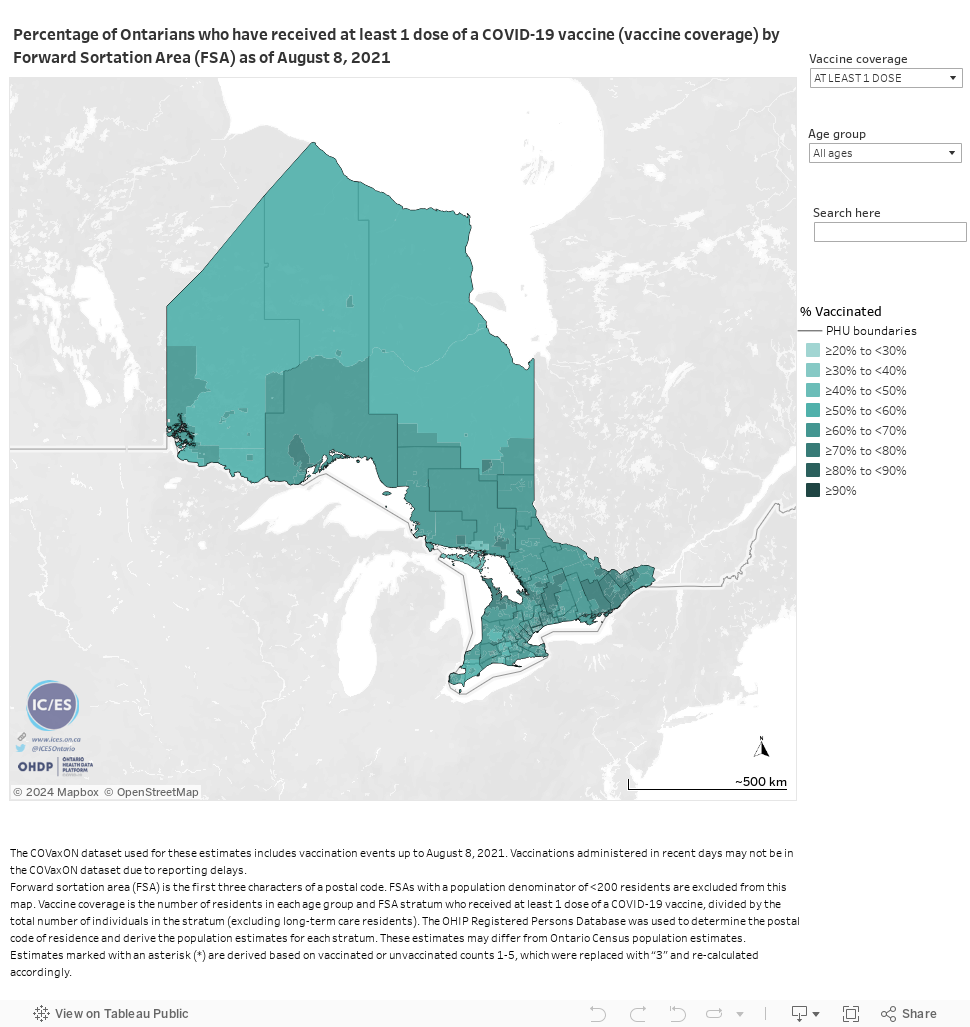
The ranking is based on the cumulative incidence of COVID-19 infection among residents living outside of long-term care facilities within each FSA as of March 28, 2021.
Neighbourhood breakdown
Cambridge residents with an N1S postal code live in an FSA that is among the lowest risk neighbourhoods in the city.
It earns a score of seven based on the number of infections to date.
The number of people per 100 who have ever tested positive sits at 2.2, while the number of people per 1,000 who had a hospitalization or death due to COVID-19 is 1.26.
The neighbourhood also has one of the highest vaccination rates, with 70.65 per cent of the eligible population getting at least one dose.
The FSA runs north along the Devil’s Creek corridor to Blair Road and George Street, west to Barries Lake, and is bordered by the Grand River along Glen Morris Road to just south to Grand Ridge Drive.
Schools in this neighbourhood include Southwood Secondary School, St. Gregory Catholic School, St. Andrew’s Senior Public School, St. Andrew’s Public School, Highland Public School, Tait Street Public School, St. Augustine Catholic School and Blair Public School.
The FSA with the N3C postal code also ranks a seven. It includes east Hespeler, Hespeler and Hespeler Village.
The number of people who have tested positive is 2.32 per 100 and the number of people per 1,000 who have required hospitalization or have died is 1.22, with 69.83 per cent of the eligible population having received at least one dose of vaccine.
Jacob Hespeler SS, Hespeler PS, Woodland Park, St. Gabriel, Silverheights and Hillcrest are included in this area.
N3H ranks a six. It takes in most of Preston starting from the intersection of Concession Road and Coronation Boulevard through Blair, east down Eagle Street to Pinebush Road, and up to Allendale Road in the northwest quadrant of the city.
Among the population of 24,802 individuals living here, 2.53 out of 100 have tested positive for COVID-19 and 1.5 per 1,000 have needed hospitalization or have died from the disease.
Among the eligible number of individuals living in the FSA, 71.65 per cent have received at least one dose of the vaccine.
It includes Grand View PS, William G. Davis, Coronation PS, Parkway, St. Joseph, Preston High School and Ryerson.
The FSA with the N1R postal code ranks a five.
It is the largest FSA in Cambridge with a population of 45,111 and covers a geographical area stretching west into North Dumfries and wrapping around the central part of the city to include the neighbourhoods of Christopher-Champlain, Downtown Cambridge, East Galt, Fiddlesticks, Flamborough, and Greenway-Chaplin.
The number of people per 100 who have tested positive to date is 2.68 and the number of people per 1,000 hospitalized is 1.7.
Of residents eligible for the vaccine, 64.89 per cent of residents living in this FSA have at least a first dose.
Schools in this area include Glenview Park, GCI, Stewart Avenue. St. Vincent De Paul Catholic School, Moffat Creek Public School, St. Peter Catholic Elementary, Elgin Street PS, Christ the King, Chalmers Street PS, Central PS, Manchester PS.
The N1P postal code ranks a five. It is a small FSA with a population of 8,481 and is located south of Myers Road, between Highway 24 and Branchton Road.
The number of people per 100 who have tested positive is 2.86 and the number of people per 1,000 who have required hospitalization or have died due to COVID-19 is 0.92.
Schools in the area include Monsignor Doyle, Cambridge Christian School, Oak Bridge Academy and Holy Spirit.
The N1T postal code ranks a four. It sits on the eastern edge of the city starting at the Fiddlesticks neighbourhood.
The number of people per 100 who have tested positive is 3.05 and the number per 1,000 who have required hospitalization or who have died is 1.13.
70.65 of the eligible population in this FSA have at least one dose.
Schools here include St. Benedict, Saginaw Public School and Clemens Mill and St. Margaret of Scotland.
The FSA with the N3E postal code ranks a two. The River Mill subdivision in west Hespeler south of Maple Grove Road represents the highest risk neighbourhood, according to the IC/ES data.
With a population of only 2,501, 4.01 people per 100 have tested positive for COVID-19 and 3.34 per 1,000 have required hospitalization or died.
65.21 per cent of the eligible population has received at least one dose.
ICES researchers say they use a “vast and secure array of Ontario’s demographic and health-related data” to update the Ontario Health Data Platform weekly, including population-based health surveys, anonymous patient records, and clinical and administrative databases.
The platform uses COVID-19 test results from the Ontario Laboratories Information System (OLIS) database and other administrative data from the ICES repository and makes the information accessible to health system stakeholders, including the Ministry of Health and Public Health Ontario, clinicians, researchers and the public.